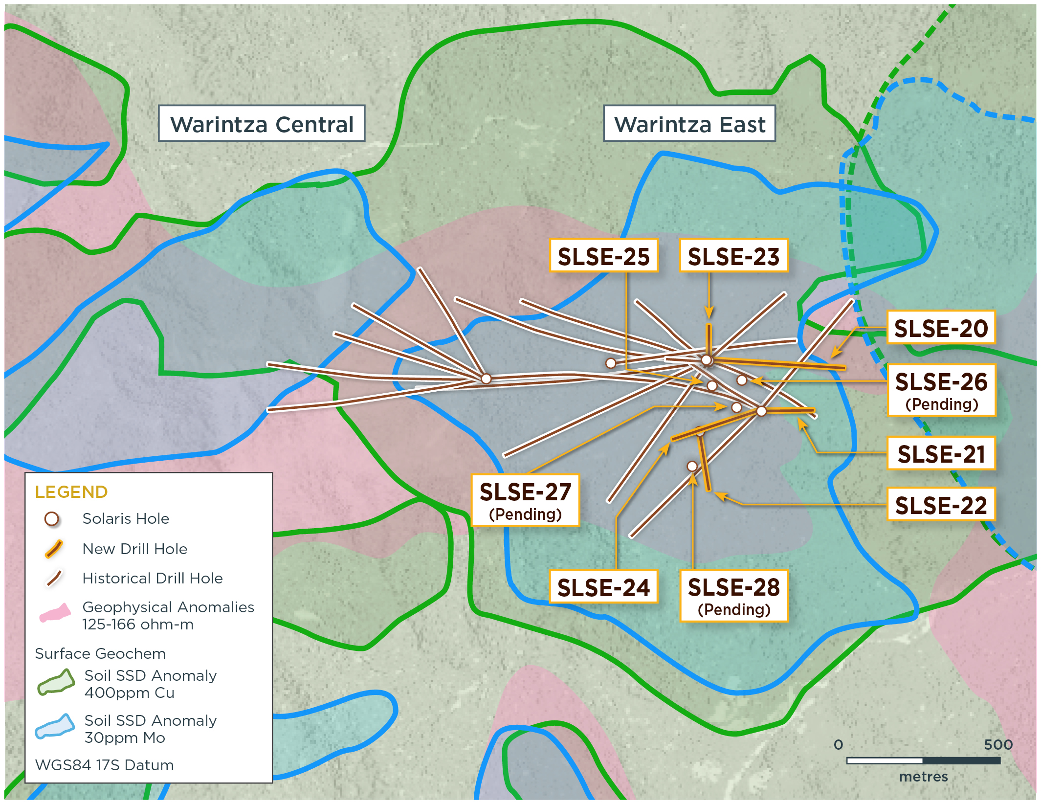
Solaris Resources Inc. (TSX:SLS) (OTCQB:SLSSF) has released assay results from several holes with the goal of expanding mineral resources and detecting a new, more concentrated porphyry center that could potentially extend to the south of the Warintza East discovery at the Warintza Project in southeastern Ecuador. The key findings, illustrated in Figure 1 and presented in Tables 1-2, are outlined below.
Mr. Jorge Fierro, Vice President, Exploration, commented in a press release: “Drilling to date confirms Warintza East as a significant porphyry deposit that adjoins Warintza Central and remains open for expansion, with a particular direction of focus to the south where extensional and step-out drilling is targeting higher grade mineralization associated with a newly identified southern porphyry center.”
Highlights from the results are as follows:
Warintza East was discovered in July 2021, with only eight holes completed prior to the cut-off for inclusion in the Warintza Central Mineral Resource Estimate (“MRE”)¹ in April 2022. Subsequent drilling has significantly expanded the dimensions of the deposit to the north, east and south, where it remains open. Recent drilling has now validated a southern vector toward stronger soil anomalism, identifying a second porphyry center producing higher grade mineralization and opening up further expansion potential in this direction.
- SLSE-23 was collared in the middle of the Warintza East drill grid and drilled north, returning 626m of 0.50% CuEq² from surface within a broader interval of 746m of 0.46% CuEq², expanding the footprint to the north where it remains open
- SLSE-24 was collared at the southeastern limit of the grid and drilled southwest into an open volume, returning 156m of 0.52% CuEq² from near surface within a broader interval of 410m of 0.30% CuEq², extending mineralization to the southwest where it remains open
- SLSE-20 was collared in the middle of the drill grid and drilled east, returning 292m of 0.45% CuEq² from surface within a broader interval of 900m of 0.30% CuEq², expanding the footprint to the east where it remains open
- SLSE-21 was collared at the southeastern limit of the grid and drilled east, returning 198m of 0.40% CuEq² within a broader interval of 1,040m of 0.33% CuEq² from surface, extending mineralization to the east where it remains open
- SLSE-25 was collared from a new central platform and drilled vertically with a small drill rig specifically used for infill purposes, returning 110m of 0.46% CuEq² from 32m depth within a broader interval, upgrading this area with near surface, high-grade mineralization
- Identification of a second porphyry center in SLSE-28, with visual interpretation suggesting potential for some of the strongest grades to date at Warintza East – the new porphyry center is located south of SLSE-22, which exited a weakly mineralized dyke into stronger mineralization over its final 40m, consistent with increased grades observed from SLSE-16 in this area (192m of 0.70% CuEq² from 350m depth within a broader interval of 712m of 0.45% CuEq² – refer to press release dated January 17, 2023)
Table 1 – Assay Results
| Hole ID | Date Reported | From (m) |
To (m) |
Interval (m) |
Cu (%) |
Mo (%) |
Au (g/t) |
CuEq² (%) |
| SLSE-25 | Apr 3, 2023 | 0 | 300 | 300 | 0.21 | 0.02 | 0.03 | 0.30 |
| Including | 32 | 142 | 110 | 0.35 | 0.02 | 0.03 | 0.46 | |
| SLSE-24 | 10 | 420 | 410 | 0.23 | 0.01 | 0.04 | 0.30 | |
| Including | 18 | 242 | 224 | 0.33 | 0.02 | 0.06 | 0.43 | |
| Including | 26 | 182 | 156 | 0.41 | 0.02 | 0.07 | 0.52 | |
| SLSE-23 | 0 | 746 | 746 | 0.36 | 0.02 | 0.04 | 0.46 | |
| Including | 0 | 626 | 626 | 0.40 | 0.02 | 0.05 | 0.50 | |
| SLSE-22 | 26 | 1080 | 1054 | 0.18 | 0.01 | 0.03 | 0.24 | |
| SLSE-21 | 0 | 1040 | 1040 | 0.26 | 0.01 | 0.04 | 0.33 | |
| Including | 92 | 290 | 198 | 0.33 | 0.01 | 0.04 | 0.40 | |
| SLSE-20 | 0 | 900 | 900 | 0.24 | 0.01 | 0.03 | 0.30 | |
| Including | 4 | 296 | 292 | 0.35 | 0.02 | 0.04 | 0.45 | |
| SLSE-16 | Jan 17, 2023 | 8 | 720 | 712 | 0.36 | 0.02 | 0.05 | 0.45 |
| Including | 76 | 184 | 108 | 0.46 | 0.02 | 0.06 | 0.57 | |
| Including | 350 | 542 | 192 | 0.59 | 0.02 | 0.07 | 0.70 |
Notes to table: True widths of the mineralized zone are not known at this time.
Table 2 – Collar Location
| Hole ID | Easting | Northing | Elevation (m) |
Depth (m) |
Azimuth (degrees) | Dip (degrees) |
| SLSE-25 | 801489 | 9648125 | 1170 | 300 | 0 | -90 |
| SLSE-24 | 801684 | 9648074 | 1221 | 722 | 250 | -65 |
| SLSE-23 | 801485 | 9648192 | 1170 | 748 | 0 | -80 |
| SLSE-22 | 801453 | 9647971 | 1234 | 1083 | 165 | -80 |
| SLSE-21 | 801684 | 9648074 | 1221 | 1071 | 90 | -82 |
| SLSE-20 | 801485 | 9648192 | 1170 | 905 | 90 | -65 |
| SLSE-16 | 801684 | 9648074 | 1221 | 845 | 225 | -45 |
| Notes to table: The coordinates are in WGS84 17S Datum. | ||||||


 Follow us on Twitter
 Become our facebook fan


Comments are closed.