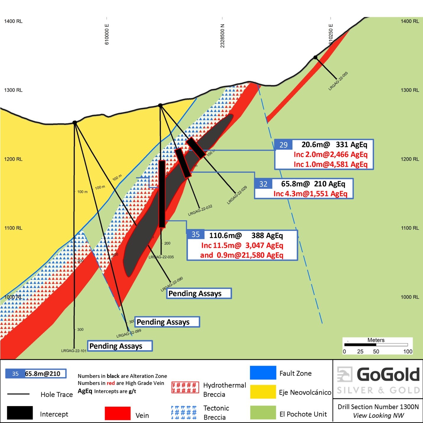
GoGold Resources (TSX:GGD) has announced a second set of drill results at its Eagle concession containing the northern strike extension of the Main Deposit on the Los Ricos South property. The recent highlights add to previous results from the company at the project. New highlights include hole LRGAG-22-035, one of the strongest holes drilled to date in the Los Ricos district, which intercepted 21,580 g/t silver equivalent (“AgEq”) over 0.9m, contained within 11.5m of 3,047 g/t AgEq within a wider intercept of 110.6m of 388 g/t AgEq.
President and CEO of GoGold Brad Langille commented in a press release: “Drilling along strike on the new Eagle concession continues to return exceptional results in both high grade and very wide widths. Today’s release of hole 35, along with hole 14 in our last release represent two of the best holes drilled in the Los Ricos district. With results like this, we are focussing the majority of our exploration on the new Eagle concession along with additional drill targets on the Main zone in Los Ricos South. Additional results are expected shortly.”

Table 1: Drill Hole Intersections
| Hole ID | Area / Vein | From | To | Length1 | Au | Ag | AuEq2 | AgEq2 |
| (m) | (m) | (m) | (g/t) | (g/t) | (g/t) | (g/t) | ||
| LRGAG-22-032 | Eagle | 48.1 | 113.8 | 65.8 | 1.36 | 107.7 | 2.79 | 209.6 |
| including | 85.8 | 113.8 | 28.1 | 2.96 | 216.6 | 5.85 | 439.0 | |
| including | 88.5 | 92.9 | 4.3 | 7.17 | 1,012.8 | 20.68 | 1,550.7 | |
| including | 88.5 | 89.1 | 0.6 | 25.00 | 3,020.0 | 65.27 | 4,895.0 | |
| LRGAG-22-033 | Eagle | 190.9 | 222.0 | 31.1 | 0.66 | 64.6 | 1.53 | 114.4 |
| including | 215.5 | 219.3 | 3.8 | 1.92 | 170.6 | 4.19 | 314.5 | |
| LRGAG-22-035 | Eagle | 69.0 | 179.6 | 110.6 | 1.64 | 264.6 | 5.17 | 387.5 |
| including | 129.0 | 140.5 | 11.5 | 11.31 | 2,198.3 | 40.62 | 3,046.7 | |
| including | 130.4 | 133.8 | 3.5 | 30.24 | 6,392.5 | 115.48 | 8,660.8 | |
| including | 130.4 | 131.9 | 1.5 | 63.24 | 12,729.3 | 232.96 | 17,472.0 | |
| including | 131.0 | 131.9 | 0.9 | 104.50 | 13,742.5 | 287.73 | 21,580.0 | |
| LRGAG-22-036 | Eagle | 87.0 | 128.0 | 41.0 | 1.26 | 83.9 | 2.38 | 178.5 |
| including | 109.0 | 128.0 | 19.0 | 2.11 | 143.8 | 4.02 | 301.8 | |
| including | 119.5 | 120.9 | 1.5 | 9.00 | 509.3 | 15.79 | 1,184.3 | |
| including | 119.5 | 120.3 | 0.8 | 12.55 | 782.0 | 22.98 | 1,723.3 | |
| LRGAG-22-037 | Eagle | 122.2 | 167.8 | 45.7 | 0.82 | 69.9 | 1.76 | 131.7 |
| including | 146.4 | 155.0 | 8.7 | 3.44 | 200.5 | 6.11 | 458.3 | |
| including | 149.9 | 151.6 | 1.7 | 12.95 | 181.7 | 15.37 | 1,152.6 | |
| including | 150.9 | 151.6 | 0.7 | 26.00 | 115.0 | 27.53 | 2,065.0 | |
| LRGAG-22-038 | Eagle | 88.0 | 124.0 | 36.0 | 1.30 | 75.7 | 2.31 | 173.0 |
| including | 106.9 | 116.0 | 9.2 | 4.81 | 256.1 | 8.23 | 616.9 | |
| including | 108.4 | 109.6 | 1.3 | 6.76 | 1,271.6 | 23.72 | 1,778.9 | |
| including | 108.4 | 109.0 | 0.7 | 7.70 | 2,030.0 | 34.77 | 2,607.5 | |
| also including | 112.6 | 115.0 | 2.4 | 12.64 | 163.6 | 14.82 | 1,111.7 | |
| including | 114.2 | 115.0 | 0.8 | 31.60 | 70.0 | 32.53 | 2,440.0 | |
| LRGAG-22-039 | Eagle | 149.7 | 169.0 | 19.4 | 0.93 | 65.8 | 1.81 | 135.7 |
| including | 156.8 | 164.4 | 7.6 | 1.87 | 145.0 | 3.81 | 285.6 | |
| including | 158.0 | 163.4 | 5.4 | 2.37 | 168.9 | 4.62 | 346.6 |
| 1. | Not true width |
| 2. | AqEq converted using a silver to gold ratio of 75:1 at recoveries of 100% |
| 3. | Hole LRGAG-22-034 did not intercept significant mineralization |
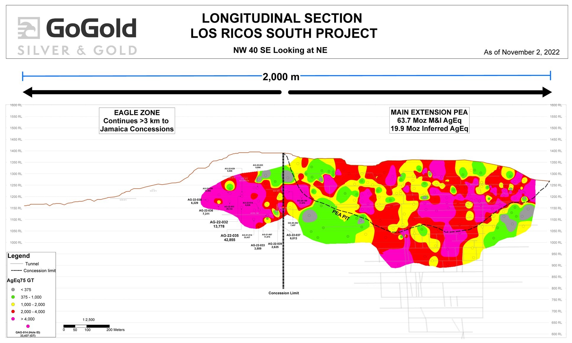
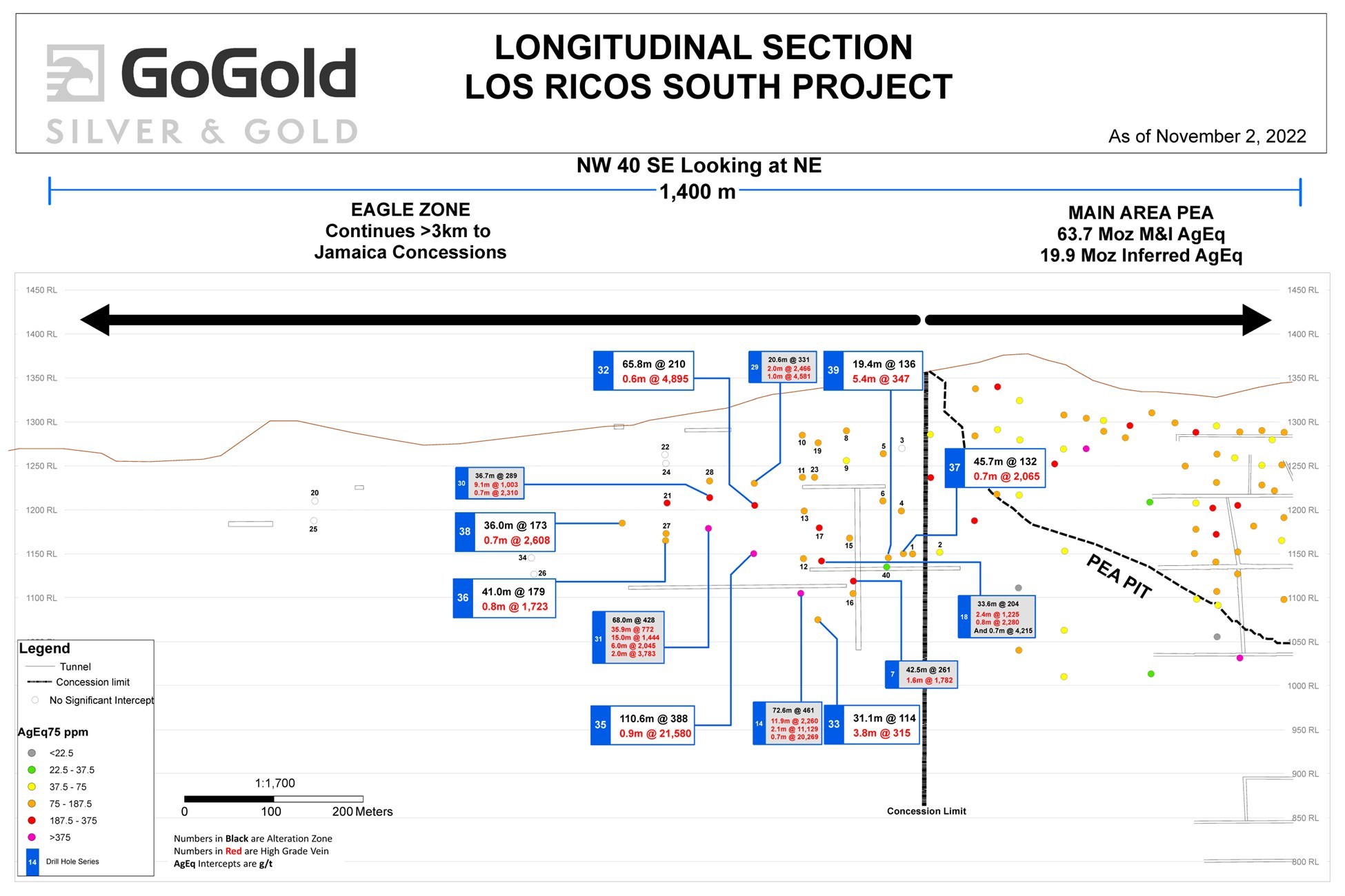
The Eagle concession adjoins the Main Deposit where the Los Ricos South Preliminary Economic Assessment (“PEA”) was released on January 20, 2021. This represents an extension to this previously defined Mineral Resource Estimate at Los Ricos South. The concession covers 1,107 hectares, including the area between the Main Deposit and the Company’s Jamaica concession located 3km to the northwest, where the Company holds the rights to additional concessions. Due diligence drilling has returned the highest grade intercepts to date in the district. These wide high grade intercepts are consistent with geophysical targets on the new concession. See Figure 1 below which shows a cross section including drill hole LRGAG-22-035.

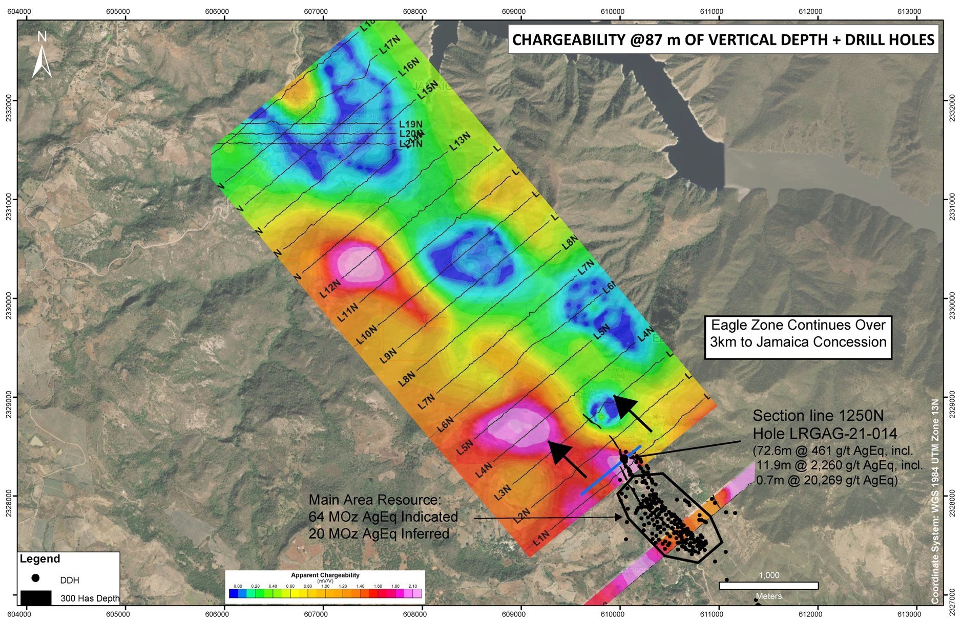
The Company has completed preliminary geological mapping, sampling, geophysical IP surveying, and has commenced a drill program at the Eagle. Mapping and geophysics indicate the Eagle structure extending in excess of 2.5km to the northwest, at which point it continues onto the Company’s previously owned Jamaica concessions. The Main Area was included in the initial Los Ricos South Mineral Resource estimate released on July 29, 2020, which included 1.1 km along strike of the mineralized trend.

While there was some historical underground mining development in the early 1900’s on the Eagle concession, there was only one historical void encountered during drilling, which suggest that the mineralization at the Eagle may be intact and not previously mined. The location and high grade intercepts may indicate the presence of a high grade ore shoot that was not previously exploited. This differs from the Main Area which has had portions of it’s high grade ore shoots mined out.
The results of the sampling and geophysical IP survey (Figure 4) appear to indicate that the mineralized structure continues in a Northerly direction from the Main Area. Significant geophysical anomalies were identified which will form targets for the drilling campaign.
The Eagle concession connects the Company’s concessions held in the southern portion of its Los Ricos South project, including the Main area where the Initial Resource was released, to its northern concessions in Los Ricos South, which includes the Jamaica exploration target. As a result, all of the concessions in Los Ricos South are now contiguous (Figure 5).
The Company exploration team has been completing detailed mapping and sampling at Jamaica over the last year and sees the same structure that was drilled in the main zone at Los Ricos South extending for several kilometres over the Jamaica concessions. This offers the potential for an additional bulk tonnage target in Los Ricos South, with continuity from the Main Area and Eagle.

Table 2: Drill Hole Locations
| Hole ID | Easting | Northing | Elevation | Azimuth | Dip | Length |
| LRGAG-22-032 | 610059 | 2328444 | 1278 | 50 | -70 | 159 |
| LRGAG-22-033 | 610057 | 2328344 | 1283 | 0 | -90 | 295 |
| LRGAG-22-034 | 609857 | 2328604 | 1244 | 50 | -45 | 271 |
| LRGAG-22-035 | 610058 | 2328443 | 1278 | 0 | -90 | 216 |
| LRGAG-22-036 | 610026 | 2328548 | 1271 | 0 | -90 | 171 |
| LRGAG-22-037 | 610090 | 2328247 | 1295 | 0 | -90 | 213 |
| LRGAG-22-038 | 609977 | 2328575 | 1265 | 50 | -50 | 139 |
| LRGAG-22-039 | 610087 | 2328271 | 1289 | 50 | -65 | 219 |


 Follow us on Twitter
 Become our facebook fan


Comments are closed.