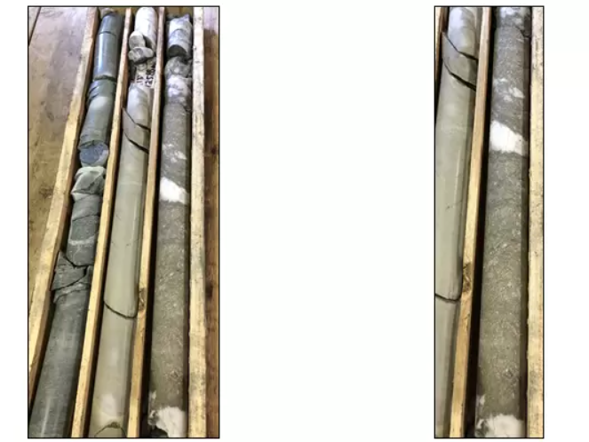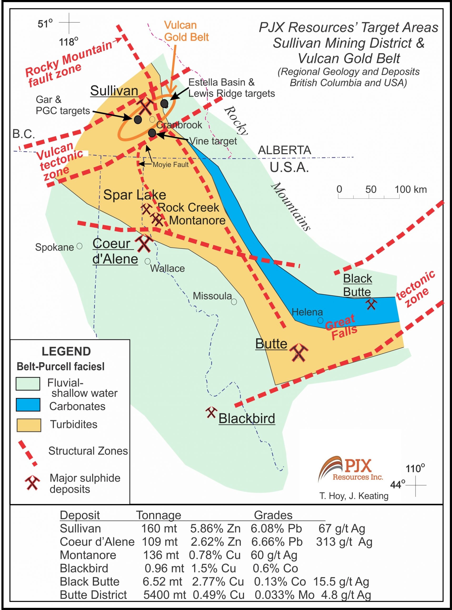
PJX Resources Inc. (TSXV:PJX) has discovered massive sulphide containing anomalous cobalt, copper, nickel, and silver in a quartz-dolomite gangue within metasediments. This mineralization appears to be similar in style to the mineralization found at the Black Butte copper-cobalt deposit, located to the south in Montana (refer to Photo-A and Fig. 1).
The discovery was made during the drilling of Mobile-MT electromagnetic (EM) and magnetic geophysical anomalies at the Lewis Ridge target in late 2022 on the Dewdney Trail Property. The mineralization is situated approximately 3 kilometres north of alkalic intrusive-related gold-copper-silver mineralization at PJX’s Estella Basin target, which was previously announced in the Sullivan Mining District and Vulcan Gold Belt of southeastern British Columbia, Canada.
John Keating, President of PJX commented in a press release: “This was the first phase of drilling to test EM and magnetic anomalies at the more than 2.5 km long and 1.5 km wide Lewis Ridge target area. Our initial thinking was that geophysics identified potential Sullivan-type zinc-lead-silver mineralization. However, drilling has discovered potential for sediment hosted copper-cobalt type deposits possibly similar to those that occur east of Butte, Montana. PJX plans to further explore and drill the Lewis Ridge copper-cobalt target area, and the previously announced new Estella Basin intrusive-related gold-copper-silver target area this year.”

Background
Geology
- Four holes (LR22-01 to LR22-04) were drilled late last year at the Lewis Ridge target to test EM and magnetic anomalies defined by an airborne Mobile-MT (EM) and Magnetic survey flown for PJX by Expert Geophysics.
- Hole LR22-02 intersected massive sulphide mineralization consisting of fine to coarse grained pyrite that has a somewhat net-textured appearance and is fractured or brecciated possibly due to folding (see Photo A above).
- The 1.42 m wide (drill width) zone with 60% massive sulphide in quartz-dolomite gangue was intersected from 125.87m to 127.29 m down hole, and analyzed 644 ppm (0.06%) Co, 819 ppm (0.08%) Cu, 144 ppm Ni and 2.66 ppm (2.6 g/t) Ag.
- The sulphide zone appears bedding parallel and possibly stratabound similar to Black Butte massive pyrite mineralization containing Co, Cu, with anomalous Ni and Ag.
- Black Butte massive pyrite locally contains tennantite (arsenic mineral); Lewis Ridge massive sulphide has 1187 ppm arsenic.
- Black Butte occurs with black shales that are correlative with the middle Aldridge geological formation. Lewis Ridge target occurs at the base of locally black graphitic and/or calcareous silts and argillites of the middle Aldridge.
- Black Butte occurs in the Helena Embayment, a shallow water environment on the east side of the Belt-Purcell rift basin and east of the Butte intrusive related Cu-Molybdenum-Ag deposits. The Lewis Ridge target area is a shallow water environment on the east side of the Belt-Purcell basin, and east of the Sullivan sediment hosted Zn-Pb-Ag deposit (see Fig. 1).
- Black Butte mineralization is associated with an east-west fault called Volcano Valley. The east-west Kimberley Fault influenced the formation of the Sullivan Deposit. The Jackleg fault at Lewis Ridge may be the eastern extension of the Kimberley fault (see Fig 2) Volcano Valley, Kimberley and Jackleg are all considered to be transverse faults in the Belt-Purcell basin.
- Lewis Ridge Target occurs along a large north-south oriented west dipping overturned anticline, and at the equivalent geological time to the Sullivan deposit located about 25 km to the west (see Fig. 3).

Geophysics – Drilling
- The Lewis Ridge zone with massive pyrite, and the overlying locally graphitic and/or calcareous sedimentary rocks are both conductive rock units. Their conductive nature help explain the large EM apparent conductivity geophysical anomaly. However, the 2 units, along with mafic sills intersected, are not magnetic and do not appear to account for magnetic anomalies (see Fig. 4).
- Cu-Co deposits also occur in Idaho. Pyrite is known to replace pyrrhotite in some of these deposits. Pyrrhotite is often magnetic. If the same type of replacement occurs at Lewis Ridge, then any pyrrhotite not replaced by pyrite may generate a magnetic anomaly.
- Hole LR22-01, drilled toward the northeast (Az 047, dip -75), intersected locally graphitic and calcareous sediments above the quartz-carbonate zone from 111.67-116.12 m. The 4.45m (drill width) zone contained minor sulphide veins and a weighted average analysis of 2410 ppm Cu with low Co, Ni, and Ag.
- Hole LR22-02, was drilled toward the southwest (Az 227, dip -80) from the same drill pad as LR22-01.
- Hole LR22-03, was also drilled toward the southwest (Az 227, dip -45) and encountered what appear to be west dipping faults and was abandoned when the hole was becoming stuck in a fault zone.
- Hole LR22-04, was drilled toward the northeast (Az 047, dip -80) to drill across the west dipping faults and test the large EM and somewhat coincident magnetic anomaly at depth (see Fig. 4 and 5). The 800 m hole drilled along the eastern limb of the overturned anticline fold and across a series of faults. This resulted in the hole remaining within the locally graphitic and/or calcareous sediment unit, and therefore did not test the potential horizon with cobalt and copper mineralization at depth that is stratigraphically lower.


 Follow us on Twitter
 Become our facebook fan


Comments are closed.