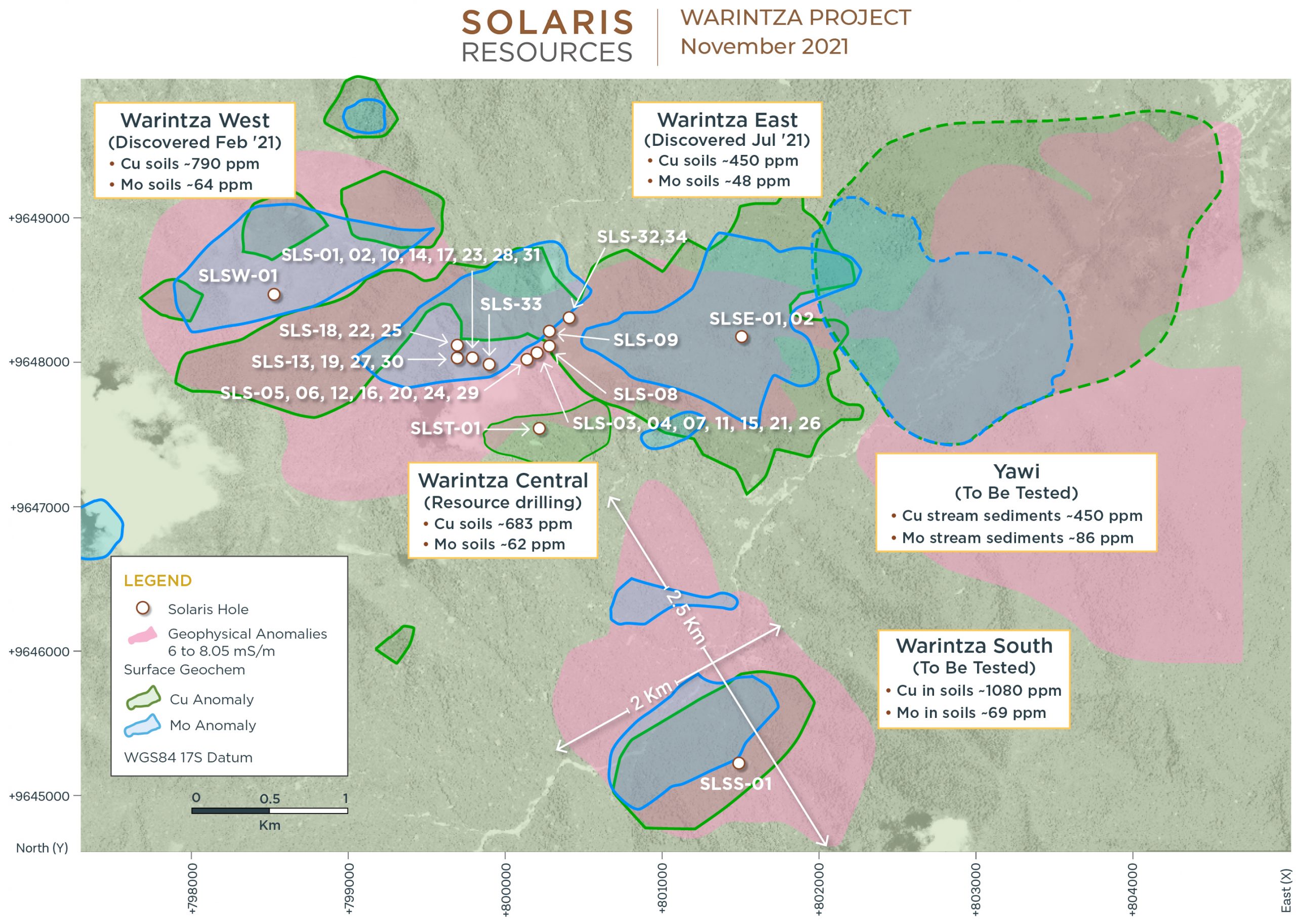
Solaris Resources (TSX:SLS) announced the commencement of maiden drilling at Warintza South this morning. In addition, updated results of detailed geophysical interpretation and geochemical sampling were delivered. The company has also refined and expanded the dimensions of the main objectives of the Warintza Project in southeastern Ecuador.
Mr. Daniel Earle, President and CEO of Solaris, said in a press release: “We are very excited to commence the first-ever drilling program at our voluminous Warintza South target, with the goal of making the fourth major discovery within our Warintza Project as we redirect our 12-rig drilling fleet toward aggressive step-out growth and discovery-oriented drilling over the balance of the year and into 2022.”
Highlights and corresponding Figures 1-3 are provided below. A dynamic 3D model featuring the updated geophysical and geochemical anomalies is available on the Company’s website.
Highlights
- Commenced maiden drilling at the Warintza South target, with the first hole collared ~3km south of Warintza Central (refer to Figures 1-3)
- The Warintza South high conductivity anomaly has dimensions more than twice the size of Warintza Central, and a similar geochemical signature where exposed at surface
- Updated interpretation has expanded the dimensions of the Warintza South high conductivity anomaly to ~2.5km x 2.0km x 0.7km and those of Warintza East and Yawi
- Additional geochemical sampling has also expanded the Warintza East anomaly further to the east and northeast where it now overlaps with Yawi
- Sampling continues to extend geochemical coverage over the sparsely sampled areas to the west and south of Warintza Central, and to targets beyond the Warintza porphyry cluster
Geophysical Reinterpretation
The Company retained Condor Consulting, Inc. (“Condor”), recognized experts in the field of airborne electromagnetics (EM), to perform detailed modelling and interpretation of the previously completed advanced airborne ZTEM survey (refer to press release dated February 16, 2021 for survey results) covering the entire 268km² Warintza and surrounding area land package.
Condor carried out a full 3D inversion of the EM and magnetic results using commercial and proprietary software producing enhanced images based on a greatly expanded dataset, including a considerable amount of additional drilling since the prior interpretation, and detailed geology, weathering and density models for the Project.
In general, the refined high conductivity volumes capture mineralization closer to surface and correlate more closely to networked sulfide mineralization in stockwork veining, with the anomalies now starting at surface and better reflecting the vertical zonation of the Warintza porphyries from higher density stockwork veining to lower density veining and disseminated mineralization.
Warintza South
Warintza South is defined by a voluminous high-conductivity anomaly located ~3km to the south of Warintza Central. The anomaly starts at surface and measures ~2.5km x 2.0km x 0.7km deep, with overlapping copper and molybdenum geochemical anomalies covering the exposed portion at surface.
Source: Solaris Resources


 Follow us on Twitter
 Become our facebook fan


Comments are closed.